February 2022 and Winter 2021-2022 St. Cloud Weather Summary
March 2, 2022
Roller Coaster Winter Ends Up Cold More Often Than Mild
February 2022 and Winter 2021-2022 Saint Cloud, MN, Weather Summary
Note: This is a summary of meteorological winter, which is defined as the three coldest months of the year (1 December through 28 February). Astronomical winter ends on the spring equinox, which will be on March 20 this year. That's the day when we get back to 12 hours of daylight. Also, note that the cold season can be used to refer to the part of the year when Minnesota can get snow (typically Oct-Apr, but can be longer) or the heating season (July 1-June 30). No, the groundhog doesn't work in Minnesota.
| Northwest Minnesota Winter of Whiteouts | ||||
| February St. Cloud Records | Lows of -20 or colder | Double Snowstorm Clobbers Central Minnesota March 21-23 |
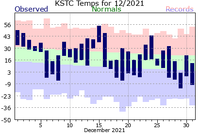
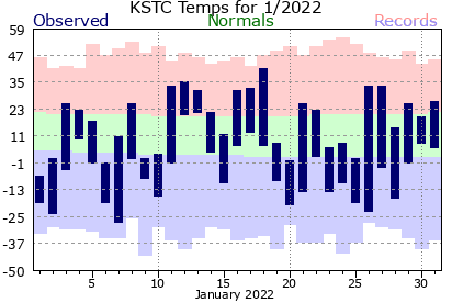
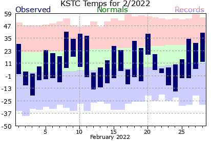
The winter of 2021-2022 has produced nearly every variety of weather possible, with the exception of widespread large snowstorms. The temperature variation has been wild all three months of winter (December, January, and February) with very few days having near average (top of blue line near green-red transition; bottom of blue line near green-blue transition). The main difference between December and the last two months has been more days on the cold side (more in the blue shading than the green).
Colder Than Average February, But No Records (Last February Was More Extreme
February 2022 continued that trend in St. Cloud. The monthly average temperature was 9.8 degrees, 6.3 degrees below average. 11 of the days had a temperature at least 10 degrees colder than average. While February was significantly cold with 18 days with a low of zero or colder, there were no daily record cold temperatures set in February or all of the meteorological winter (December 1-February 28). This is in great contrast to last February, which had one of the more intensely cold two-week periods during February. There were two record cold high temperatures set last February and more days with a high of zero or colder and a low of -20 or colder (see table below).
|
St. Cloud Cold Temperatures |
February 2021
|
2021-2022 Season
|
February 2022
|
2021-2022 Season so far
|
Cold Season Average
|
| Highs of 0 or colder |
8
|
8
|
0
|
3
|
4.3
|
| Lows of 0 or colder |
15
|
24
|
18
|
49
|
42.7
|
| Lows of -20 or colder |
5
|
5
|
1
|
5
|
5.4
|
| 5 straight highs of 0 or colder: longest since Jan. 30-Feb. 4, 1996 | 13 straight lows of 0 or colder: longest since Jan. 3-15, 1999 | ||||
While February 2022 did have more lows of zero or colder, February 2021 had a streak of 13 days with a low of zero or colder, the longest since 1999. Overall, February 2021 (7.6 degrees, 7.6 degrees colder than average) was colder than February 2022, but it was the only colder than average month during the winter. Both December 2020 and January 2021 had above average temperatures with no highs of zero or colder or lows of -20 or colder, so that season ended up being 1.4 degrees above average.
Significantly Cold Winter (Dec-Feb), but Not Extremely So
With February 2022 matching January 2022, the winter season of 2021-2022 has ended up with an average temperature of 12.1 degrees, 3.1 degrees colder than average. That was slightly colder than the winters of 2017-2018 and 2018-2019 (12.5 degrees). Over the past 15 years, the longest period of colder than average winters was from 2007-2008 through 2010-2011. Each season had an average winter temperature between 9.0 and 13.5 degrees with only one those winters being milder than this year. Still, the most recent really cold winter was 2013-2014 (5.5 degrees, 5th coldest winter in St. Cloud records).
Season of Wild Temperature and Pressure Swings...
Still, as the monthly temperature graphs show, there was a lot of back and forth to the temperature cycle. That's because the primary steering wind pattern across North America was a west-northwest to east-southeast flow. That produced frequent series of low pressure systems and air mass changes from the very mild air along the eastern slopes of the Canadian Rockies and southeastward (where there has been very little snowfall for most of the winter; see seasonal loop of snow depth from NWS NOHRSC) and a series of arctic air masses that have dominated north central and northeastern Canada. This pattern produced a series of strong weather systems, often producing strong low pressure systems moving southeastward near or across Minnesota and shoving cold arctic highs over Minnesota. This pattern played havoc with the sea-level pressure, often producing swings of half an inch to more than an inch of pressure change within a day (see 30-day graph of St. Cloud sea level pressure from MesoWest), along with the temperature swings (see 30-day graph of St. Cloud temperature from MesoWest). Some of the peaks over 40 degrees produced daily high temperatures for a few hours in the middle of the night.
...With Frequent High Winds, Leading to Abnormal Numbers of Whiteouts in Northern and NW MN
The wild pressure swings also meant strong winds from the southeast ahead of any storm and from the northwest after the low went by. Since the northern half of Minnesota (from the St. Cloud-Alexandria areas northward) had persistently deep snow cover (see seasonal loop of snow depth from NWS NOHRSC) that was often refreshed, this has led to a high number cases of poor visibility in blowing snow in much of the northern half of Minnesota and blizzard conditions in the Red River Valley. The National Weather Service in Grand Forks has issued 11 blizzard warnings through the end of February this year, the most recorded in its history. Even other parts of Minnesota have frequently seen wind gusts over 40 MPH.
Top 20 in Measurable Snow Days, But Snow Not Much Higher Than Average
Despite the frequency of storms, the general northwest-to-southeast winds have kept most of the moisture well to the south of Minnesota during these storms. Unlike December, 3rd wettest December with 2.01 inches of precipitation, this has resulted in a series of frequent, but light snowfalls for central and northern Minnesota. While there have been 35 days (20th highest) with measurable snowfall in St. Cloud for the cold season so far, they have only produced 40.4 inches of snowfall (still 5.3 inches above average). This has also been true in Fargo, where the seasonal snowfall is only 46.2 inches, 7.2 inches above average. The frequent light snow, especially during the cold air outbreaks, has still kept a snowpack top with some powder on it, causing problems when the winds pick up.
In January (10.8 inches, 2.0 inches above average) and February (9.7 inches, 0.9 inches above average), St. Cloud State University (the official snowfall observing site for St. Cloud) has picked up slightly above average snow, but only December (17.8 inches, 11th snowiest December in St. Cloud records) has seen significant snowfall. This has also meant that St. Cloud has only had a glancing blow from the few storms that produced intense snowfall. The February 20-21 storm, which again produced a foot to a foot and a half of snow just to the north from Morris and Alexandria through Detroit Lakes through Little Falls and Mora and onto Duluth, produced 4.4 inches of snow over the two days in St. Cloud. There still hasn't been a single day with at least 5 inches of snow in St. Cloud, compared to the two out-of-season storms last winter (October 20 and November 10). The more frequent powdery snowfalls has produced a much better Nordic skiing and snowmobiling season than last year in northern and central Minnesota.
10th Wettest (Tie) Winter in St. Cloud, Mostly Fueled by December High Moisture Storms
The liquid precipitation in that snow (0.78 inches) was slightly above average in February (0.59 inches). For the meteorological winter (Dec-Feb), the total melted precipitation has been 3.37 inches, tied with 1949-1950 for 10th wettest. The bulk of that occurred in the 2.01 inches of the 3rd wettest December,, which produced 17.8 inches of snow, just out of 10 snowiest.
Upcoming: Potential for Spring Flooding
While the frequent storm pattern seems continue through the first week of March, the future comes with an assessment of the flooding potential from all of that snow in central and northern Minnesota. The Red River Valley has an above average chance of moderate to major flooding since the area of deepest snowpack is over that region. The Upper Mississippi River and St. Croix River Basins are also covered by a lot of snow, but there isn't that much in the St. Croix and Minnesota River Valleys, and the relatively dry conditions before the ground froze means that the soil can absorb quite a bit of moisture. So, the best guess is an average risk of flooding with the best chance north of the Minnesota River with less than average risk of flooding further to the south. All of that depends on how much precipitation and additional snow we get in the next month and how quickly a thaw occurs.
| Northwest Minnesota Winter of Whiteouts | ||||
| February St. Cloud Records | Lows of -20 or colder | Double Snowstorm Clobbers Central Minnesota March 21-23 |
|
Temperatures (°F)
|
Feb 2022
|
Normal
|
|
| Average High Temperature (°F) |
21.6
|
25.7
|
|
| Average Low Temperature (°F) |
-1.9
|
6.5
|
|
| Mean Temperature for February (°F) |
9.8
|
16.1
|
|
|
February Extremes
|
Temperature(°F)
|
Date
|
|
| Warmest High Temperature for Feb 2022 (°F) |
42
|
Feb. 8
|
|
| Coldest High Temperature for Feb 2022 (°F) |
1
|
Feb. 3
|
|
| Warmest Low Temperature for Feb 2022 (°F) |
20
|
Feb. 20
|
|
| Coldest Low Temperature for Feb 2022 (°F) |
-20
|
Feb. 3
|
|
|
Record Temperatures in February 2022
|
Temperature(°F)
|
Date
|
Old Record
|
| No Temperature Records Set | |||
|
Temperature Thresholds
|
Number of Days
|
Normal
|
|
| February 2022 Days with High Temperatures <= 32°F |
20
|
20.0
|
|
| February 2022 Days with High Temperatures <= 0°F |
0
|
0.8
|
|
| February 2022 Days with Low Temperatures <= 32°F |
28
|
27.8
|
|
| February 2022 Days with Low Temperatures <= 0°F |
18
|
12.2
|
|
| February 2022 Days with Low Temperatures <= -20°F |
1
|
2.9
|
|
|
Liquid Equivalent Precipitation (in)
|
Feb 2022
|
Normal
|
|
|
February 2022 Saint Cloud Airport Melted Precipitation (in)
|
0.78 inch
|
0.59
|
|
|
February Extremes
|
Precipitation (in)
|
Date
|
|
|
Most Daily Precipitation in February 2022
|
0.28 inch
|
Feb 22
|
|
|
Record Precipitation in February 2022
|
Precipitation (in)
|
Date
|
Old Record
|
|
No records set
|
|||
|
Precipitation Thresholds
|
Number of Days
|
Normal
|
|
| February 2022 Days with Measurable (>= 0.01 inch) Precipitation |
9
|
5.7
|
|
| February 2022 Days with >= 0.10 inch Precipitation |
2
|
2.1
|
|
| February 2022 Days with >= 0.25 inch Precipitation |
1
|
0.8
|
|
| February 2022 Days with >= 0.50 inch Precipitation |
0
|
0.3
|
|
| February 2022 Days with >= 1.00 inch Precipitation |
0
|
0.0
|
|
|
Snowfall (in)
|
Feb. 2022
|
Normal
|
|
|
February 2022 Saint Cloud Airport Snowfall (in)
|
9.7
|
8.9
|
|
|
Snowfall Thresholds
|
Number of Days
|
Normal
|
|
| February 2022 Days with Measurable (>= 0.1 inch) Snowfall |
9
|
5.7
|
|
| February 2022 Days with >= 1.0 inch Snowfall |
4
|
2.6
|
|
| February 2022 Days with >= 2.0 inch Snowfall |
2
|
1.4
|
|
| February 2022 Days with >= 5.0 inch Snowfall |
0
|
0.2
|
|
|
February Extremes
|
Snowfall (in)
|
Date
|
|
|
Most Daily Snowfall (in) in February 2022
|
3.0
|
Feb 22
|
|
|
Record Snowfall (in) in February 2022
|
Snowfall (in)
|
Date
|
Old Record
|
| No records set | |||
| Northwest Minnesota Winter of Whiteouts | ||||
| February St. Cloud Records | Lows of -20 or colder | Double Snowstorm Clobbers Central Minnesota March 21-23 |
Winter (Dec 1-Feb 28) 2021-2022 Statistics
|
Temperatures (°F)
|
Winter 2021-2022
|
Normal
|
| Average High Temperature (°F) |
23.2
|
24.2
|
| Average Low Temperature (°F) |
1.1
|
5.3
|
| Mean Temperature for Winter (°F) |
12.1
|
14.8
|
|
Winter Extremes
|
Temperature
|
Date
|
| Warmest High Temperature for Winter 2021-2022 (°F) |
55 (set daily record warm high)
|
Dec 15, 2021
|
| Coldest High Temperature for Winter 2021-2022 (°F) |
-7
|
Jan 1, 2022
|
| Warmest Low Temperature for Winter 2021-2022 (°F) |
37 (set daily record warm low)
|
Dec 15, 2021
|
| Coldest Low Temperature for Winter 2021-2022 (°F) |
-28
|
Jan 7, 2022
|
|
Temperature Thresholds
|
Number of Days
|
Normal
|
|
Cold Season 2021-2022 |
67
|
87.6
|
|
Cold Season 2021-2022 |
8
|
4.3
|
|
Cold Season 2021-2022 |
0
|
0.6
|
|
Cold Season 2021-2022 |
121
|
170.4
|
|
Cold Season 2021-2022 |
49
|
42.7
|
|
Cold Season 2021-2022 |
5
|
5.4
|
|
Cold Season 2021-2022 |
0
|
0.6
|
|
Liquid Equivalent Precipitation (in)
|
Winter 2021-2022
|
Normal
|
|
Saint Cloud Winter Melted Precipitation (in)
|
3.37 (tied with 1949-1950 for 10th wettest)
|
2.18
|
|
Precipitation Thresholds
|
Number of Days
|
Normal
|
| Winter 2021-2022 Days with Measurable (>= 0.01 inch) Precipitation |
33
|
19.4
|
| Winter 2021-2022 Days with >= 0.10 inch Precipitation |
7
|
6.5
|
| Winter 2021-2022 Days with >= 0.25 inch Precipitation |
3
|
2.3
|
| Winter 2021-2022 Days with >= 0.50 inch Precipitation |
0
|
0.6
|
| Winter 2021-2022 Days with >= 1.00 inch Precipitation |
0
|
0.0
|
|
|
||
|
Snowfall (in)
|
Winter 2021-2022
|
Normal
|
|
Winter 2021-2022 Snowfall (in)
|
38.3
|
25.5
|
|
Seasonal Snowfall (in) for Cold Season 2021-2022 (October 1, 2021-February 28, 2022)
|
40.4
|
34.9
|
|
Snowfall Thresholds
|
Number of Days
|
Normal
|
| Cold-Season 2021-2022 Days with Measurable Snowfall |
35
|
24.8
|
| Cold-Season 2021-2022 Days with >= 1.0 inch Snowfall |
16
|
10.6
|
| Cold-Season 2021-2022 Days with >= 2.0 inch Snowfall |
8
|
5.5
|
| Cold-Season 2021-2022 Days with >= 5.0 inch Snowfall |
0
|
1.0
|
| Northwest Minnesota Winter of Whiteouts | ||||
| February St. Cloud Records | Lows of -20 or colder | Double Snowstorm Clobbers Central Minnesota March 21-23 |
Updated March 2, 2022


Send comments to: raweisman@stcloudstate.edu