May and Spring 2021 Saint Cloud Weather Summary
April and May Showers Often Absent in Minnesota
May and Spring 2021 Saint Cloud Weather Summaries
The weather trends have been quite fickle during the 2020-2021 cold seasons coming to end. There have been both incredibly warm periods, like St. Cloud's 7th mildest March, periods of intense cold, like 2 weeks in February, and big snowstorms at odd times in October and November. However, the consistent trend all during the cold season was a precipitation shortage in North Dakota and parts of Minnesota. Those conditions spread across all of Minnesota, except for the northeast and southeast (see National Weather Service Minnesota rainfall map). The May rainfall at the St. Cloud Regional Airport was only 2.30 inch, 1.30 inch below average. And, the Minnesota map shows less than 2 inches from western and northern Stearns County through most of west central and north central Minnesota. A swath between Baudette, Bemidji, Alexandria, and Brainerd had less than half an inch of rain (blue). So, the area of unusual dryness on the US Drought Monitor from June 10 shows that weak drought conditions have again spread through western and southern Minnesota. The rest of the state is shown to be drier than average. Minnesota is generally on the eastern edge of much drier than average conditions that extend westward to the West Coast. Some parts of the Northern Rockies have had their lowest cold season and spring snowfall on record, which portends problems for the wildfire season.
In Minnesota, the consequences of the dry conditions has been the prevalence of wildfires on any breezy day with a temperature warmer than 70. Also, river and streamflow has been lower than average, especially in central Minnesota where parts of the St. Louis, Crow Wing, St. Croix and even the Mississippi Rivers have less than 25 percent of the average streamflow. Rivers in southern Minnesota are doing better and extreme northwestern Minnesota got some important rain in the severe storm outbreak on May 19 and 20.
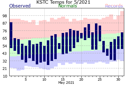
The temperature pattern was again quite inconsistent. After St. Cloud barely missed a 90-degree high on May 1, the northwest to southeast air flow allowed some cool leftovers from north central Canada to dominate Minnesota's weather for most of the following two weeks. St. Cloud's high temperature stayed 65 or cooler from May 2 through 11. This included a hard freeze on May 8 and 11 (lows of 27 and 26, respectively). Milder weather dominated the middle of the month, although the warm air was still quite dry. An air mass for May 19-22 was increasingly warm and humid. That regime produced 80-degree highs on May 21 and 22, the first since May 1, and some uncomfortable nights with lows in the 60's. There were thunderstorms in the area, but the strongest ones either hit northern Minnesota or produced a day of short-lived tornadoes in south central Minnesota. Once that air left Minnesota, we returned to a cooler pattern, during which the high temperature stayed below 70 on May 26-30. There were two days of unusual late season frost on May 29 and 30. St. Cloud Regional Airport didn't quite get to the freezing point, which would have made it among the latest 10% of St. Cloud frosts. It was also within a degree or two of a low temperature record.
Just to keep the roller coaster temperature theme going, some usual early season heat that spent the end of May in the Pacific Northwest and the Northern Rockies moved into St. Cloud, beginning on June 3, producing 7 straight days of 90-degree highs and tying or breaking 4 record warm high temperatures.
The overall May temperature ended up being 56.0 degrees, 0.2 degrees cooler than average, despite most of the month being considerably away from average. Only of the 31 May days were within 5 degrees of the daily average.
For the spring season (March 1-May 31), St. Cloud ended up being 2.1 degrees above average with a temperature of 45.6 degrees. The March through May precipitation was 5.92 inches, 1.1 inches below average.
| Spring High Temperature Thresholds | 2021 | Median Date |
| First 50 degree high | March 7 | March 16 |
| First 60 degree high | March 9 | April 4 |
| First 70 degree high | April 4 | April 17 |
| First 80 degree high | April 5 | May 4 |
| Last Frost |
May 12 (33 on May 29, 10th percentile) |
May 10 |
| Last 36 degree or colder | May 29 (30th percentile) | May 23 |
| Outbreak of Mini-Tornadoes May 19-20 | |||
|
Temperatures (°F)
|
May 2021
|
Normal
|
|
| Average High Temperature (°F) |
68.4
|
68.8
|
|
| Average Low Temperature (°F) |
43.5
|
44.2
|
|
| Mean Temperature for May (°F) |
56.0
|
56.5
|
|
|
Temperature Thresholds
|
Number of Days
|
Normal
|
|
| May 2021 Days with High Temperatures =>90°F |
0
|
0.04
|
|
| May 2021 Days with Low Temperatures <= 32°F |
7
|
2.8
|
|
|
Cold-season 2020-2021 Days with Low Temperatures <= 32°F |
182
|
170.4
|
|
|
Cold-season 2020-2021 Days with High Temperatures <= 32°F |
74
|
87.7
|
|
|
|
Spring First/Last High Temperatures | ||
|
May Extremes
|
Temperature(°F)
|
Date
|
|
| Warmest High Temperature for May 2021 (°F) |
89
|
May 1
|
|
| Coldest High Temperature for May 2021 (°F) |
26
|
May 11
|
|
| Warmest Low Temperature for May 2021 (°F) |
66
|
May 22
|
|
| Coldest Low Temperature for May 2021 (°F) |
27
|
May 9,12
|
|
| Record Temperatures in May 2021 |
Temperature(°F)
|
Date
|
Old Record
|
| No records set | |||
|
Precipitation (in)
|
May 2021
|
Normal
|
|
|
May 2021 Precipitation (in)
|
2.30
|
2.95
|
|
| Growing Season (April-May) Precipitation (in) |
5.43
|
5.52
|
|
|
May Extremes
|
Precipitation (in)
|
Date
|
|
|
Most Daily Precipitation in May 2021
|
0.60 inch
|
May 27
|
|
|
Record Precipitation in May 2021
|
Precipitation (in)
|
Date
|
Old Record
|
|
No Records Set
|
|||
|
Precipitation Thresholds
|
Number of Days
|
Normal
|
|
| May 2021 Days with Measurable (>= 0.01 inch) Precipitation |
11
|
10.7
|
|
| May 2021 Days with >= 0.10 inch Precipitation |
7
|
6.5
|
|
| May 2021 Days with >= 0.25 inch Precipitation |
3
|
4.4
|
|
| May 2021 Days with >= 0.50 inch Precipitation |
2
|
2.2
|
|
| May 2021 Days with >= 1.00 inch Precipitation |
0
|
0.7
|
|
|
|
Complete list of Saint Cloud May Records Link to 10 Wettest/Driest Mays |
||
|
Snowfall (in)
|
May 2021
|
Normal
|
|
|
May 2021 Snowfall (in)
|
None
|
0.1
|
|
|
Seasonal Snowfall (in) for Cold Season 2020-2021
|
45.2
|
46.1
|
|
|
Temperatures (°F)
|
Spring 2021
|
Normal
|
| Average High Temperature (°F) |
56.2
|
54.7
|
| Average Low Temperature (°F) |
33.5
|
32.2
|
| Mean Temperature for Spring (°F) |
45.6
|
43.5
|
|
Temperature Thresholds
|
Number of Days
|
Normal
|
| Spring 2021 Days with High Temperatures => 90°F |
0
|
0.6
|
| Spring 2021 Days with High Temperatures <= 32°F |
2
|
11.0
|
| Spring 2021 Days with Low Temperatures >= 70°F |
0
|
0.03
|
| Spring 2021 Days with Low Temperatures <= 32°F |
44
|
46.5
|
| Spring 2021 Days with Low Temperatures <= 0°F |
0
|
3.6
|
| Spring 2021 Days with Low Temperatures <= -20°F |
0
|
0.1
|
| Spring 2021 Days with Low Temperatures <= -30°F |
0
|
0.6
|
|
Liquid Equivalent Precipitation (in)
|
Spring 2021
|
Normal
|
|
Spring Melted Precipitation (in)
|
5.92
|
7.07
|
|
Precipitation Thresholds
|
Number of Days
|
Normal
|
| Spring 2021 Days with Measurable (>= 0.01 inch) Precipitation |
33
|
26.2
|
| Spring 2021 Days with >= 0.10 inch Precipitation |
18
|
14.7
|
| Spring 2021 Days with >= 0.25 inch Precipitation |
13
|
9.3
|
| Spring 2020 Days with >= 0.50 inch Precipitation |
7
|
4.4
|
| Spring 2020 Days with >= 1.00 inch Precipitation |
0
|
0.7
|
|
Snowfall (in)
|
Spring 2021
|
Normal
|
|
Spring 2021 Snowfall (in)
|
8.1
|
11.0
|
|
Seasonal Snowfall (in) for Cold Season 2020-2021
|
45.2
|
46.1
|
|
|
||


Send comments to: raweisman@stcloudstate.edu