St. Cloud, MN Weather Forecast
Tuesday, July 15, 2025 3:25 AM
Prepared by Bob Weisman, SCSU Meteorologist and Professor Emeritus
Showers and Thunderstorms Likely This PM and Tonight, Then a Trip to the Refrigerator Mid-Week
Moisture Arriving at All Levels for Thunderstorm Outbreak Second Half of Today
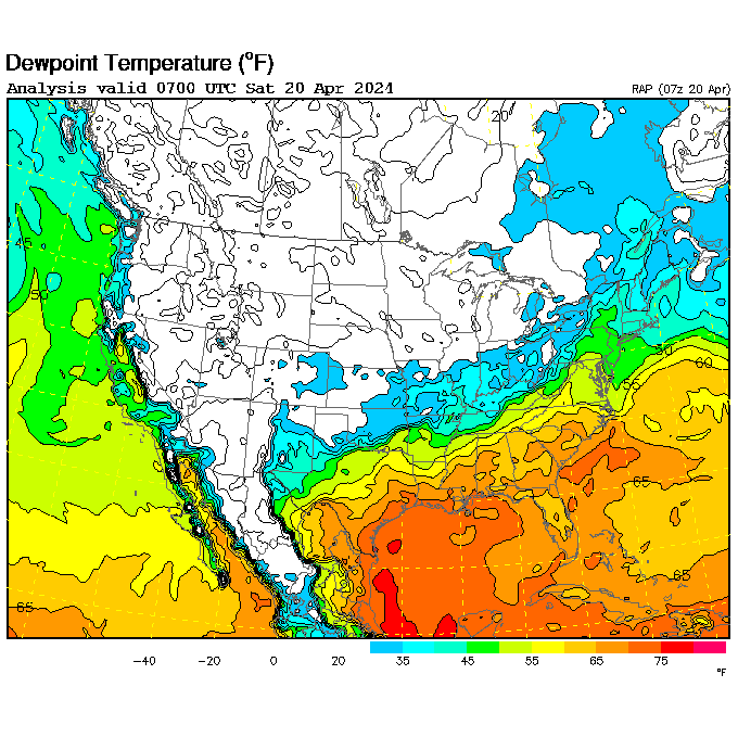
The storm that will pull the front from its current position in northern Minnesota (see latest NWS WPC North America zoom-in map) through the state by Wednesday is now moving southeastward through British Columbia into northern Idaho and northwestern Montana (see counterclockwise rotation on the College of DuPage North America mid-troposphere water vapor loop). On the cool side of the warm front, showers and thunderstorms have developed and pushed eastward from the North Dakota-Canadian border into northern Minnesota (set number of frames to 200 on the College of DuPage north central US radar loop). At the same time, the south low-level flow ahead of this system (see NWS Aviation Weather Center METAR map) has pulled both low-level moisture (oppressive dew points in the 70's in central and southern Minnesota on the UCAR hourly dew point chart) and middle-level moisture from the North American monsoon (see blossoming thunderstorms from Colorado to Mexico on Sunday night redevelop in southwest-to-northeast flow through South Dakota on the College of DuPage North America mid-troposphere water vapor loop). Showers and thunderstorms began yesterday afternoon in Wyoming and Colorado, with more during the evening in South Dakota (see College of DuPage north central US radar loop). The South Dakota storms produced some straight-line wind damage and the North Dakota storms produced some large hail.
Perhaps a Few Early Storms; Better Chance Afternoon and Overnight
The storms over South Dakota have weakened during the early morning hours, so I only expect a few scattered showers and thunderstorms during the pre-dawn hours, perhaps lingering into the morning rush hour. However, the strongest outbreak of thunderstorms will likely begin early this afternoon and continue well into the evening in central Minnesota. Those afternoon and evening storms could produce large hail and straight-line damaging winds (NWS Storm Prediction Center has upped the threat to category 2 of 5 in central Minnesota). There is also a chance for heavy rainfall (see Day 1 NWS WPC quantitative precipitation forecast). Some areas where several waves of thunderstorms repeat could end up with over 3 inches of rainfall, producing a risk of localized flooding (see category 2 of 4 area from southwest through central and into northeastern Minnesota on the Day 2 NWS WPC Excessive Rainfall Outlook).
The threat for severe weather will ease after early this evening, but there will still be a chance of heavy rainfall until the early morning hours. Tomorrow, we will see a mostly cloudy day with occasional rain showers throughout the day.
Temperature Whiplash Today (Sultry) Versus Tomorrow
There will be a huge swing in how today feels versus how tomorrow feels, since the cold front will push through Minnesota early tomorrow morning. The early departure of the overnight showers and thunderstorms means that central Minnesota could see a decent supply of sun today. That would push temperatures into the middle 80's, this time with more oppressive humidity. Some heat indices could reach the lower to middle 90's (see NWS Minnesota hourly weather round-up for latest temperatures, dew points, and heat indices of 88 or higher). There is a chance for 90 degrees in southern Minnesota, but I think the afternoon storms in central Minnesota will develop too early to allow full heating. Note that the National Weather Service has issued a heat advisory for the Twin Cities Metro Area.
After the cold front moves by early tomorrow, temperatures will likely hold in the 60's with any rainy period producing temperatures only around 60 degrees. I don't think the cold front will get to central Minnesota quickly enough to allow this cool air to move in before midnight tonight; otherwise, St. Cloud would have a shot at tomorrow's record cool high of 66, set in 2009. There will also be a stiff northeast breeze.
Sun Returns Thursday and Friday....
Much cooler than average temperatures will continue through Friday. If we clear up on Wednesday night, temperatures will reach the lower 50's and may reach the upper 40's (note that Thursday's record cool low is 44, set in 1906). We should have a better supply of sunshine on Thursday and Friday, which will allow daytime highs to climb back into the 70's, but that will be 5-10 degrees short of the mid-July average high in the low to middle 80's.
...Likely Through Smoke (Not Quite as Bad as Over the Weekend??)
Unfortunately, this mid-week air will be coming from southern Manitoba or western Ontario. Unfortunately, the air pollution levels have remained orange in this area, including Winnipeg (see EPA fire and smoke map). So, that would produce some smoke issues in central Minnesota, as early as tomorrow morning as the cold front comes through.
The big worry is that the air quality has again deteriorated in much of Saskatchewan and southern Alberta with again red (unhealthy for all) and even purple (very unhealthy; as bad as the worst levels seen in northern Minnesota during the weekend outbreak) I've run the computer forecast checking the low-level air source through Wednesday and the southern Manitoba-Ontario border area keeps showing up. However, this computer forecast from firesmoke.ca shows that the overall densest part of the smoke plume (orange and brown areas) will move into Minnesota tomorrow. That doesn't guarantee that all of the smoke will get to the ground. At the very least, we will lose a few degrees off the daytime high on Thursday and perhaps Friday and might see a couple of degrees milder overnight lows.
Note that the Minnesota Pollution Control Agency has issued another air quality alert in northern Minnesota through 11 PM tonight. The leftovers from the weekend smoke outbreak are still in a chunk of the Iron Range, the Boundary Waters, and into Duluth (see latest Minnesota air quality index). This will ease eastward today, but a new surge from southern Manitoba will move in as the cold front moves back into central Minnesota. There is the possibility of more alerts covering the cooler regime that will move in tomorrow.
Next Rain Chance Friday Night into Saturday?? Back to Seasonable Temperatures, Uncomfortable Humidity???
We will remain near the main storm track, which will move weather systems from west-northwest to east-southeast. The next possible rain event after all of the rain winds down tomorrow will be Friday night into Saturday as warmer air tries to move over the leftover cool air. The air flow won't have a long time to draw very moist air from the south, but some mid-level moisture could still be nearby in the central Rockies. I have a less than 50-50 shot at showers and thunderstorms on Friday night into Saturday. We should persist in at least seasonably warm temperatures through the weekend, but with continued uncertain chances for showers. And, smoke will be a possibility as long as the general air flow continues from the northwest.
Detailed St. Cloud, MN, and Vicinity Forecast
Confidence Level: "The Bugs Are Waiting for Me to Mow the Lawn"
Tuesday 7/15/2025: Mixed clouds and sun through midday with a few scattered morning showers and thunderstorms. Showers and thunderstorms likely redeveloping during the afternoon. Heavy downpours, straight-line damaging winds, and large hail may be possible. Still very warm with oppressive humidity. High: between 82 and 87. Winds: SW 15-25 MPH with higher gusts. Chance of measurable rainfall: 40% during the morning, 80% during the afternoon.
Tuesday Night: Showers and thunderstorms likely. Heavy rainfall is possible. Still uncomfortably humid. Low: between 57 and 62. Winds: NE 10-20 MPH. Chance of measurable rainfall: 90%.
Confidence Level: "Extra Bugs Will Come From Every Home on the Block to Hover Around My Head"
Wednesday 7/16/2025: Mostly cloudy with a chance for occasional rain or showers. Breezy, much cooler, and not nearly as humid. Smoke by afternoon? High: between 65 and 70. (record cool high: 66 in 2009) Winds: NE 8-15 MPH. Chance of measurable rainfall: 50%.
Wednesday Night: Partly clear with diminishing wind and much cooler. Areas of fog possible by morning. Smoke issues? Low: between 48 and 53. (record cool low: 44 in 1906) Winds: NE 5-15 MPH evening, light NE late. Chance of measurable rainfall: 10%.
Thursday 7/17/2025: Sunshine, perhaps dimmed by smoke, mixing with clouds during the afternoon. A slight chance for a late day sprinkle. Lighter winds, still a bit cool, and continued drier. High: between 70 and 75. Winds: SE 5-10 MPH. Chance of measurable rainfall: 10%.
Thursday Night: Partly clear with perhaps some smoke. Maybe some early morning fog. Not quite as cool. Low: between 52 and 57. Winds: SE 5 MPH. Chance of measurable rainfall: 10%.
Confidence Level: "Enough Bugs Will Fly into My Mouth to Throw Off My Diet"
Friday 7/18/2025: Mixed clouds and smoky sunshine. A little warmer, and turning noticeably humid. A slight chance of a late day shower. High: between 73 and 78. Winds: S 5-15 MPH. Chance of measurable rainfall: 20%.
Friday Night: A chance of scattered showers and thunderstorms. Milder and uncomfortably humid. Low: between 62 and 67. Winds: SE 5-15 MPH. Chance of measurable rainfall: 40%.
Saturday 7/19/2025: A chance for early showers and thunderstorms, then partial clearing by afternoon. Back to summer-like temperatures and still uncomfortably humid. High: between 80 and 85. Winds: E 5-15 MPH. Chance of measurable rainfall: 40%.
Extended: Uncertain chances for showers and thunderstorms Sunday into early next week??? Continued seasonably warm Sunday and Monday and uncomfortably humid??? A chance of very warm mid-week temperatures???
Forecast Confidence (10 - "The Rabbits Will Thump Even Though I Fed Them"; 0 - "The Rabbits Will Offer To Groom My Bald Spot"): 6 Tuesday, 7 Tuesday night, 4 Wednesday through Thursday night (mostly uncertain due to smoke potential), 3 Friday, 2 Friday night and Saturday.
Yesterday's High: 88°F; Overnight Low (through 3 AM Tuesday): 76°F
St. Cloud Airport 24-Hour Melted Precipitation (through 3 AM Tuesday): None; SCSU 24-Hour Precipitation (through 3 AM Tuesday): None
| July 15 Historic Data | High | Low |
| Average Temperatures | 84°F | 60°F |
| Record Temperatures | 102°F (1931) | 77°F (1931) |
| 61°F (1962) | 44°F (1912) |
Next Update: Wednesday, July 16, 2025 6 AM
Links
Surface
- Full UCAR surface chart menu
- NWS Minnesota Hourly Weather Round-Up
- NWS: Last 72 hours of St. Cloud Observations
- MesoWest: Last 48 hours of St. Cloud Observations
- Full NWS Aviation Center Zoom-In Map
- Full College of DuPage surface map menu (click on surface map and area)
- NWS WPC Latest North American zoom-in surface map
- NWS WPC surface map menu
- Weisman's scale of Minnesota Muggy
- NWS WPC Short-Range forecast map
- NWS WPC 0-7 day forecast map loop
- NWS WPC three-day steering wind forecast
- US Air and Sports Net MN Wind Chill map
- NWS NOHRSC Snow Analyses
Satellite
- College of DuPage Satellite and Radar Menu
- Colorado State RAMDIS Menu
- NASA GHCC Satellite Menu
- NWS GOES Geostationary Satellite Menu (Tropical Atlantic)
- University of Wisconsin-Madison SSEC US Real-Time Satellite Imagery
- 7-day N. American Composite IR loop
- Worldwide Geostationary Satellite Looper (use pull-down menu for different earth areas)
- High-resolution MODIS images (polar orbiter)
- Zoom-in on active tropical cyclones
Radar
- NWS Upper Mississippi Valley radar loop
- NWS Chanhassen radar loop (fancy graphics)
- NWS Chanhassen radar loop (no terrain; faster running)
- NWS Chanhassen radar loop and derived products (from College of DuPage)
- NWS National Radar Loop
- College of DuPage Satellite and Radar Menu (links to velocity and dual polarization data)
- Environment Canada Canadian Prairies radar loop
- Environment Canada Ontario radar loop
Current Watches/Warnings
- US Watch/Warning Map from National Weather Service
- NWS Twin Cities Regional watch warning map
- Today's NWS Storm Prediction Center severe weather outlook
- Active Tropical Cyclones in eastern Pacific and Atlantic from NWS National Hurricane Center
- Potential Flooding Areas from the NWS Weather Prediction Center
- Air Quality Index from the Minnesota Pollution Control Agency
Weather Safety
- NWS Weather Safety Page
- CDC Natural Disaster and Severe Weather Safety
- Severe Weather Safety from the National Weather Service
- NWS Hot Weather and Sun/Ultraviolet Safety
- NWS Winter Storm Safety
- NWS Cold Weather Safety
- Yesterday's Storm Prediction Center severe weather reports are here
- NWS Hurricane Safety Page
- NWS National Hurricane Center overview of storm surge (coastal flooding)
- Minnesota MPCA hourly Air Quality Index
- Minnesota DNR Wildfire danger
- US Average Weather Related Deaths from NWS
Ground and Air Travel
- Minnesota (high bandwidth)
- Minnesota (faster loading)
- Iowa (high bandwidth)
- Iowa (faster loading)
- North Dakota
- South Dakota
- Wisconsin
- Manitoba
- Ontario
- National Weather Service Enhanced Data Display Forecast Tool
- Airline Flight Delays and Cancellations from FlightAware.com
Climate
- Yesterday's Saint Cloud Climate Summary
- St. Cloud Weather Summaries by month
- Minnesota State Climatology Office weekly growing season rainfall maps
- Minnesota State Climatology Office create your own precipitation table
- NWS Create Your Own Rainfall Map
- Yesterday's High Temperature Map from NWS/SUNY-Albany
- This Morning's Low Temperature Map from NWS/SUNY-Albany
- Daily High/Low/Precip/Snowfall by Month (1997-current)
- National Weather Service Saint Cloud Daily Weather Site
- Saint Cloud Daily Normals, Records, and Extremes
- Bob Weisman's Ultimate Saint Cloud Climate Page
- NWS National High/Low Temperature Table and 2 Day Forecast
Drought
- St. Cloud Growing Season Rainfall and Departure from normal (at the bottom of this forecast each day)
- National Drought Mitigation Center's US Drought Monitor (updated on Thursdays)
- Minnesota Weekly Crop Progress and Condition Report from USDA NASA (updated on Mondays)
- DNR Waters Streamflow Report (updated on Mondays)
- NWS Create Your Own Rainfall Map
- More Drought Links (from the State Climatology Office, Minnesota DNR)
- Minnesota Major City Daily High/Low/Precip by Month (from the Minnesota Climatology Working Group)
- DNR Forestry/Fire Conditions page
Let me know what you think about this forecast and discussion by emailing SCSU meteorology professor Bob Weisman. Please note that I make the forecast, not the weather!
Are you interested in studying meteorology? If so, go to the Atmospheric and Earth Sciences Department home page.